

DDOE operates an extensive 24-hour air monitoring network that measures air pollutants in the outdoor ("ambient") air and meteorological conditions. Monitoring data is crucial in determining compliance with EPA’s national ambient air quality standards. EPA approved District’s Ambient Air Monitoring Network Plan describes the air quality measurement network.
The measurements support the timely reporting of air quality forecasts, sent to EPA and then onto MWCOG. It also tracks the long-term air quality to gauge the effectiveness of control and abatement strategies.
The District's air monitoring network contains monitoring stations located at the McMillan Reservoir, River Terrace Education Center, Takoma Recreation Center, Anacostia Freeway Benning Road Ramp and King Greenleaf Recreation Center.
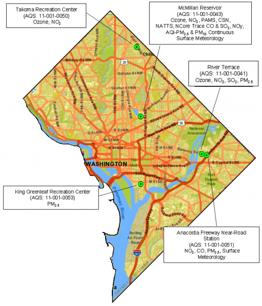
Each of the five station locations is sited based on population density and distribution, the location of stationary and mobile sources, and the historic concentration of particular pollutants. The air that is monitored is representative of the air that most District residents and visitors are breathing.
Each station has equipment that screens the concentration of pollutants of concern in the outdoor air. DDOE staff visit the sites on a daily or weekly basis to perform routine data checks, performance audits, and scheduled maintenance. They also change filters and, depending on the type of sampler, retrieve raw data or achieve other quality assurance or quality control data.
This network allows the District to conduct the following major activities and functions:
Continuous Monitoring - Real-time measurements are taken using automated sensoring equipment on an hourly basis. Measurments include:
- Carbon monoxide
- Nitrogen dioxide
- Sulfur dioxide
- Ozone
- PM2.5
Real-time ozone and PM2.5 data is submitted to EPA's AirNOW database and is posted on the Clean Air Partners, MWCOG, and National Park Service websites.
Semi-Continuous Monitoring - Air quality samples are collected using filters or canisters, typically every day or once in every 3 or 6 days, to develop 24-hour average data. The filters are sent to a lab daily for analysis.
- Photochemical Assessment Monitoring Station (PAMS) - Measures ozone as well as ozone precursors and meteorological conditions, which contribute to the formation of ozone, during the ozone season (May to September).
- PM2.5 Chemical Speciation Network (CSN) - Measures PM2.5 as well as fine particulate precursors.
- National Air Toxics Trends Station (NATTS) - The NATTS program is a national monitoring network designed to assess trends in high-risk urban air toxics including black carbon, heavy metals, and hexavalent chromium-VI. The District hosts the first NATTS station in all of EPA Region 3.
Data generated from this monitoring network is carefully reviewed, edited and analyzed prior to submittal into EPA's national air quality database called the Outdoor Air Data-Air Quality Subsystem (Air Data-AQS), as required under the Clean Air Act.
For more inquiries, please contact Dr. Rama Tangirala (use contact information below).
For more inquiries, please contact Rama Tangirala (use contact information below).